


Boise Voting District, King County, Washington
About
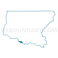
Outline

Summary
| Unique Area Identifier | 685672 |
| Name | Boise Voting District |
| County | King County |
| State | Washington |
| Area (square miles) | 6.16 |
| Land Area (square miles) | 6.06 |
| Water Area (square miles) | 0.11 |
| % of Land Area | 98.27 |
| % of Water Area | 1.73 |
| Latitude of the Internal Point | 47.18861940 |
| Longtitude of the Internal Point | -122.03114830 |
Maps


Graphs
Select a template below for downloading or customizing gragh for Boise Voting District, King County, Washington


Neighbors
Neighoring Voting District (by Name) Neighboring Voting District on the Map
- Voting District 31-627, Pierce County, WA
- Voting District 31-628, Pierce County, WA
- Voting District 31-654, Pierce County, WA
- Voting District 31-655, Pierce County, WA
- Voting District 31-670, Pierce County, WA
- ENM 31-0411 Voting District, King County, WA
- ENM 31-0418 Voting District, King County, WA
- ENM 31-3248 Voting District, King County, WA
- ENM 31-3492 Voting District, King County, WA
- Madison Voting District, King County, WA
- Osceola Voting District, King County, WA
- Sierra Voting District, King County, WA
- White River Voting District, King County, WA
Top 10 Neighboring County Subdivision (by Population) Neighboring County Subdivision on the Map
- Puyallup CCD, Pierce County, WA (152,823)
- Enumclaw Plateau CCD, King County, WA (63,367)
- Buckley CCD, Pierce County, WA (21,379)
Top 10 Neighboring Place (by Population) Neighboring Place on the Map
Top 10 Neighboring Unified School District (by Population) Neighboring Unified School District on the Map
Top 10 Neighboring State Legislative District Lower Chamber (by Population) Neighboring State Legislative District Lower Chamber on the Map
Top 10 Neighboring State Legislative District Upper Chamber (by Population) Neighboring State Legislative District Upper Chamber on the Map
Top 10 Neighboring 111th Congressional District (by Population) Neighboring 111th Congressional District on the Map
Top 10 Neighboring Census Tract (by Population) Neighboring Census Tract on the Map
- Census Tract 314, King County, WA (5,780)
- Census Tract 702.07, Pierce County, WA (4,948)
- Census Tract 703.07, Pierce County, WA (4,876)
- Census Tract 313.02, King County, WA (4,371)
- Census Tract 315.02, King County, WA (3,876)
- Census Tract 313.01, King County, WA (2,487)